 rus
rus
 eng
eng
Fisheries Information SeaStar - OrbMap
Save time and fuel when operating your fishing vessel
Since 1997, GeoEye has been developing and providing fish-finding solutions tailored to the unique needs of pelagic fishing operations worldwide. These services are used successfully by purse seiners, longliners, trolling vessels and mid-water trawlers to minimize search time and reduce fleet operating costs. The SeaStar Fisheries Information Service combines ocean plankton data with oceanographic and meteorological data sets from several other satellite imaging systems. The SeaStar oceanographic imagery products are processed daily by GeoEye’s team of oceanographers, and are delivered directly to your vessel at sea for viewing on the ship’s personal computer.
To maximize the use of the information, GeoEye provides the OrbMapTM software, training and technical support to all customers. OrbMap software enables captains and fleet managers to view and manipulate the map layers, easily translating satellite imagery and oceanographic data into smart fishing decisions.
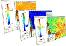
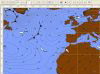
GeoEye creates SeaStar Fish Finding Maps with oceanographic information from several satellites and other sources - OrbMap.
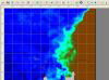
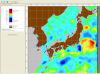
Display and interpret the ocean and weather condition with OrbMap software, which includes:
- C-MAP nautical charts
- 3D oceanographic data views
- MasterCast fishing ground analysis tool
- Oceanographic analysis and recommendations
Example of OrbMap charts:
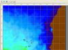
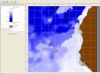
- Ocean plankton concentrations (ocean color)
- Sea surface temperatures
- Sea surface currents
- Sub-surface temperatures
- Thermocline depth estimates
- Sea surface height anomalies (altimetry)
- Ocean salinity estimates
- Comprehensive marine weather and forecasts
SeaStar Pro Service Provides commercial grade oceanographic and weather information for many types of pelagic fishing vessels. The SeaStar Pro Service includes oceanographic maps delivered daily (showing areas of high fish-finding probabilities), detailed oceanographic analysis performed by GeoEye’s oceanographers, OrbMap software for viewing and manipulating map data, and technical support and training from GeoEye staff, international agents and business partners. GeoEye offers this stand alone data service with accurate and detailed weather forecast information delivered by email to vessels at sea.
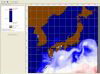
OrbMap Software with MasterCast:
With the easy-to-use OrbMap software, captains can combine their local knowledge with the digital oceanographic map data to create customized images showing where fish are likely to concentrate or gather. OrbMap 7 includes MasterCast, an interactive tool which automatically analyzes oceanographic data and identifies fishing grounds based on the captain’s preferred conditions. OrbMap has a NMEA interface for the onboard GPS device. OrbMap also supports 14 languages.