 rus
rus
 eng
eng
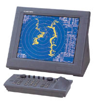
Radars Furuno FAR-2117 / 2127 / 2137
- Advanced signal processing for improved detection in rough sea.
- LCD display with clear representation.
- Designed to comply with SOLAS carriage in bearing frequencies for vessels up to 10,000 GT.
- Up to four radars can be interswitched in the network without an extra device.
- Automatic plotting/tracking of 100 targets manually or automatically acquired.
- Easy operation by customizable function keys, trackball/wheel palm module and rotary controls.
- Low spurious magnetrons meeting ITU-R unwanted emission standards.
- Displays up to 1000 AIS equipped targets.
- Control unit with a full keyboard.
- Improved characteristics of target detection.
- Type approval from RMRS.
Replies to the demands:
- IEC 60936-1 for vessel radars
- IEC 60936-2 for radars HSC
- IEC 60872-1 for ARPA
- IEC 60872-2 for ATA
- IEC 60945 general demands
- IMO MSC.64 (67) Addition 4
- IMO A.823 (19)
Technical specifications
| Parameters, function | Values |
| Antenna type | XN-12AF (X-BAND, 4') 1,9° х 20° XN-20AF (X-BAND, 6.5') 1,23° х 20° XN-24AF (X-BAND, 8') 0,95° х 20° SN-30AF (S-BAND, 10') 2,3° х 25° SN-36AF (S-BAND, 12') 1,8° х 25° |
| Speed of rotation | X-BAND: 24 or 42 turns/min S-BAND: 21 (50 Hz), 26 (60 Hz) or 45 turns/min |
| Transceiver frequency | X-BAND: 9410 МHz +30МHz S-BAND: 3050 МHz +30МHz |
| Output power | FAR-2117 - 12 kW FAR-2127 - 25 kW FAR-2137S - 30 kW |
| Display type | 23,1"" colored LCD, SVGA 1280x1024 pixel |
| Dimensions | 470 х 353 mm |
| Effective diameter | 340 mm |
| Echo's color | Yellow, green or white in 32 combination |
| Scale intervals of range | 0.125, 0.25, 0.5, 0.75, 1.5, 3, 6, 12, 24, 48, 96 nm |
| Intervals of range ring | 0.025, 0.05, 0.1, 0.25, 0.5, 1, 2, 4, 8, 16 nm |
| Minimum range | 30 m on a scale 0,75 nm |
| Minimum target range detection | 30 m on a scale 0,75 nm |
| Accuracy of ring range | 0,20% |
| Working mode | True course, true north, relative motion |
| Map | 1500 points to create coastlines, own ship safety contour, isolated underwater dangers, buoys, traffic routing systems, prohibited areas, fairways as required by IMO |
| Heading sensor | Furuno GPS compass SC-60/120 is recommended as gyro reserve |
| Acquisition | 100 targets (for instance, manually 50, automatic 50) |
| Tracking | Automatic tracking of all acquired targets in 0.1-32 nm |
| Guard zone | 2 zones with width 0.5 nm |
| Past positions | 5 or 10 past positions at intervals 30 sec., 1,2,3,6 min |
| Speed vector length | True or relative 30 s., 1, 3, 6, 12, 15, 30 min |
| Collision warning | CPA limit 0.2 to 10 mile: TCPA limit 0-99 min |
| Trial maneuver | Dynamic or static, with selected delay time |
| AIS functions | entering necessary data |
| Map | 1500 points to create coastlines, own ship safety contour, isolated underwater dangers, buoys, traffic routing systems, prohibited areas, fairways as required by IMO |
| Power supply: | |
| Processor | 24 VDC или 115/230 VAC 50/60 Гц 440 VAC, 50/60 Гц (преобразователь) |
| Display | 24 VDC или 115/230 VAC 50/60 Гц 440 VAC, 50/60 Гц (преобразователь) |
| Antenna | 230 VAC, 60 Гц или 115 VAC, 60 Гц, 230 VAC, 60 Гц 440 VAC, 60 Гц (преобразователь) |
A scope of delivery
- Display unit MU-201CR
- Processor RPU-013
- Keyboard RCU-014
- Trackball RCU-015
- Antenna with cable, 15/20/30/50/100 m
- Power supply PSU-007 for FAR-2137S
- Standard spare parts and mounting tools
- RMRS certificate