rus
rus
 eng
eng
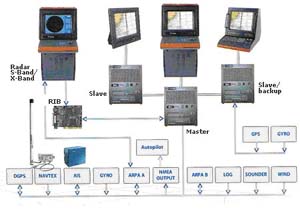
Charts system Transas Navi Fisher 3000
Navi-Fisher 3000 is an up-to-date electronic chart system ensuring safety at sea, helping to improve efficiency of fishing operations and, as a result, to increase catch and reduce running costs.
Usage of world collection of charts in Transas TX-97 format, a possibility to edit charts manually.
Drawing all moving objectives in radar area to electronic chart with the help of ARPA function. Receiving the next weather parameters: pressure, speed and wind direction, considerable sea roughs. Planning of vessel moving route considering possible risks and decreasing of fuel consumption.
3-D model making of bottom relief based on data about depths on electronic chart and also based on the additional information entered by the user. Work with echosounder: echogram, bottom profile along the route, isobaths, which were taken out from charts TX-97 format, echosounder depth line, which was installed by the user.
Technical specifications
| Parameters, function | Values |
| Charts usage | Of all official formats including vector format TX-97, ENC. Is possible to reflect up to 6 charts simultaneously. |
| Marine journal | Automatic maintenance of electronic vessel journal |
| Chart correction | Delivery of renewed charts on СD every three months renewal every 2 weeks by the Internet |
| "Info" function | Additional information about any object or a mark on electronic chart |
| Flows and currents | Data base concerning ebbs and flows, levels of flow and season and surface currents. |
| Plane tables | Creating valuable fishing plane tables |
| 3D model of bottom | Reflection of sea bottom relief under symbol of proper vessel, or in any point by user’s choice. |
| Alarm signaling | antigrounding - approaching to navigational risks route - vessel deviation from the route target/radar - events, which are connected with objectives and with sensors chart areas - approach to zones of separation sensors - data monitoring from connected sensors network аlarms - monitoring of net configuration state |
| Work with echosounder | Current depth and units of measure Echogram Relief of sea bottom according to active route Projection of vessel itself on bottom surface Isobaths received from charts TX-97 Route points, their names Trawl models with adjustments of length and depth wires |
| Records reproduction | Reproduction of all fishing operations |
| Route planning | Creating a route including up to 999 route points |
| Tracks | Track of vessel itself Trawl track Track from SARP, processor radar or AISTrawl track |
| Radar reflection | Superposition of "raw" radar picture above the chart Automatic marking and escorting till 500 objectives simultaneously Record of "raw" radar reflection on hard disk of PC |
| Navtex information | Automatic counting of received by Navtex system messages Processing, separation of position data, of area, which transmit stations and themes |
| Weather module | Getting weather forecast for 5 days by e-mail |
| Integration with AIS | Reflecting objectives of AIS on the screen Full information about objectives Sending and receiving messages Objectives identification according to the name, MMSI and call-sign Marking of chosen objectives on the chart |
| Search-and-rescue operations | Creating routes, which are according to one of scheme of rescue distressed |
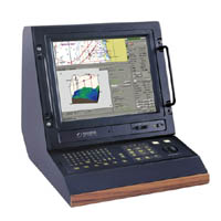
A scope of delivery
- Display;
- A set of mounting tools.
Configuration